No doubt that modern navigation technology – GPS & mapping apps – have made navigation much easier. Navigation apps however, still have a lots of opportunity for improvement. Here’s my rant take on the current state of smartphone navigation apps.
A navigation application usable for long distance travel needs to have a features that are oriented toward long distance travel rather than cityscapes, entertainment & lifestyle. We’ve found Here, Sygic, and Google Maps to come close to what we need, though because none of them are adequate to replace the others we often run more than one at the same time.
Here’s what I need in a travel-orientated navigation & mapping app:
- Good Routing and Navigation. All of the navigation apps that I’ve tried will do basic navigation. I think that Google Maps is better at real-time navigation and routing – but have no problem depending on the others. Unfortunately Google Maps is by far the most annoying to use.
- No bugs. Seriously. We’ve hit bad bugs in every mapping app that we’ve tried. Google Maps on Android Auto hangs or crashes on every phone/vehicle combination that we own – most often while navigating through an unfamiliar city and making multiple lane changes. Here and Sygic hang or crash regularly. At one point in time Sygic made a ‘bling’ noise once for every POI along the route – so for a 700 mile route you’d have to listen to a thousand ‘bling’ noises before it would finally shut up. (That bug is fixed). Here just simply crashes when it gets confused.
- A useable user interface while driving. Guess what – mapping apps get used while you are driving. No kidding. An app that requires you to poke at the UI for basic functionality forces you to divert your attention from the road. Multiple pokes means longer diversions. I suspect that the Google Maps UI team has never actually driven across the country. If the had, they’d know how to fix the UI on their app. Sygic‘s UI is more usable, and has a handful of alternate UI’s that can be used in place of the default (Heads-Up, Dashcam, Real View). Here has a simple, uncluttered UI – great for navigating, but not as nice for finding POI’s along the route.
- Downloadable maps. Too many of our routes still have marginal or no cell service. If the map is not downloaded, it’s not a map. That eliminates Waze and marginalizes the value of Google Maps. Here and Sygic have maps that are easy to download state-by-state or entire regions. Google’s maps can be downloaded, but the process is obnoxious, clunky, error-prone, and has no way of ensuring that you have a complete set of maps for the area in which you intend to travel. If you don’t align the boxes just right you can have a gap in the maps and end up with broken navigation. For example – if we are planning a trip out west but don’t know exactly where we’ll end up, downloading a complete set of maps for the western half of the US is a genuine pain in the ass. Download a chunk, re-name the chunk to something other than ‘Map 17’, and guess whether or not it’s overlapping the chunks you already downloaded. Repeat dozens of times. Dumb.
- Don’t annoy me when I stop for gas or potty breaks. I’m on the Interstate and I pull off at a wayside rest or gas station. The mapping app panics and keeps telling me how to get back on the highway. It’s been 300 miles since I last filled gas (Google knows that – it’s in my location history) and I’m at a gas station. Guess what – I need gas. I don’t need a robot voice telling me to get back on the highway. Give me a ‘STFU’ button, or better yet – use your vast AI capabilities to infer that I need gas and leave me alone for a few minutes.
- Android Auto Compatibility. Google – whose business model is you – doesn’t seem to want competing map applications to have access to Android Auto. Their own navigation app is a poor choice for long distance travel, yet they prevent competitors from leveraging Android Auto. They have a thousand radio and podcast apps and two mapping apps. Thanks Google. I love you too. (Though this may soon change.)
- Show me a #$%^& compass. I navigate by mentally positioning myself in an internalized map of the real world, so I always orient myself relative to the compass. I don’t navigate by landmarks. Knowing which way is north keeps me oriented in space, keeps my from driving around in circles, and alerts me to poor routing choices by my navigation app. Show me a compass please.
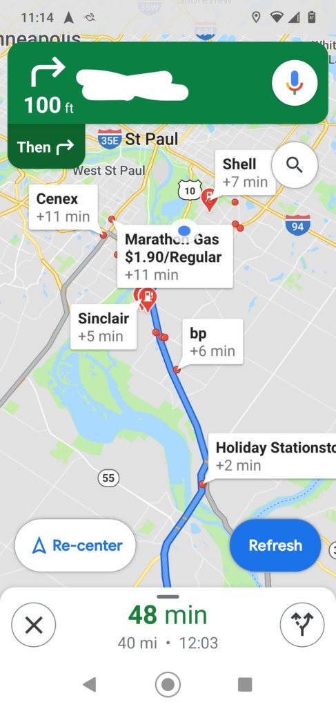
- Configurable POI (Point of Interest) searches. When traveling, I need my navigation app to tell me the distance to the next gas station or rest area and nearby grocery stores. I don’t need to know where the next bar, restaurant, or coffee shop might be. I don’t go to those places. Sygic lets me configure which POI’s are displayed on the map, shows me the distance in miles to the POI, and shows the POI’s on the map without user intervention. Perfect. I have 100 miles left in my gas tank and the next gas station is 30 miles down the road. Now I know that I’m not going to run out of gas. Google Maps lets me search for POI’s by poking at the display while I’m driving but doesn’t let me decide which POI’s to search – and instead of showing the distance to the gas station, it shows me how far off the route. With Google maps, after I poke the screen twice I know that the gas station stop will add six minutes to my trip, but without a bunch more distracting pokes I have no way of knowing if it’s ten miles down the road or a hundred. Dumb.

- Routing based on custom speed limits. We don’t drive our campervan over about 65mph. Route selection that assumes that we’ll drive at the 80mph speed limit will favor Interstate routes when more direct local routes might be just as fast if you factor in our self-imposed 65mph limit. As far as I know, that feature isn’t on any of the mapping apps that I’ve tried.
We still use road atlases and state maps. None of the mapping applications provide an overview of a potential route with enough detail, and none of the apps are useful for finding interesting sights off the mapped route. A 13″ x 18″ paper map shows an overview that has far more resolution and detail than 5.5″ phone or 8″ dashboard display. For some reason the mapping apps drop map detail as you zoom out. Paper maps don’t do that. Recreational atlases also help locate areas where there might be lots of outdoor recreation – something that mapping apps don’t do well. Paper maps also work very well when you have no cell service.
We don’t use a dedicated device (Garmin or TomTom) for navigation, though perhaps we should.
Maybe this was a rant. 😁

Leave a reply to Jamison Cancel reply